Earth:LeChee Rock
| LeChee Rock | |
|---|---|
| Leche Benchmark[1] | |
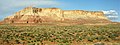
 Southwest aspect | |
| Highest point | |
| Elevation | 5,900 ft (1,800 m) [1] |
| Prominence | 730 ft (220 m) [1] |
| Parent peak | Point 5940[1] |
| Isolation | 11.39 mi (18.33 km) [1] |
| Coordinates | [ ⚑ ] : 36°51′49″N 111°18′35″W / 36.8636028°N 111.3095948°W [2] |
| Geography | |
Lua error in Module:Location_map at line 522: Unable to find the specified location map definition: "Module:Location map/data/Arizona" does not exist.
| |
| Location | Navajo Reservation Coconino County, Arizona, U.S. |
| Parent range | Colorado Plateau |
| Topo map | USGS LeChee Rock |
| Geology | |
| Age of rock | Jurassic |
| Type of rock | Sandstone |
LeChee Rock is a 5,900-foot-elevation (1,800 m) sandstone feature located south of Lake Powell, in Coconino County of northern Arizona.[2] It is situated nine miles (14 km) east-southeast of the town of Page, eight miles (13 km) east of the community of LeChee, and 7.5 miles (12.1 km) south of Tower Butte, on Navajo Nation land, where it towers over 900 feet (270 m) above the surrounding terrain as a landmark of the area. It can be seen from nearby Arizona State Route 98, or from as far away as Alstrom Point. LeChee (Łichíí) in Navajo language means red, referring to burgundy-colored leaves of a medicinal plant.[3] The spelling for this geographical feature's name was officially adopted in 2004 by the U.S. Board on Geographic Names, prior to that it was officially Leche-e Rock.[2]
Geology
LeChee Rock is located in the southern edge of the Great Basin Desert on the Colorado Plateau. It is composed of Romana Sandstone overlaying the Escalante Member of Entrada Sandstone, capped by the Salt Wash Member of the Morrison Formation. Beneath the sandstone, along the base of this feature, is reddish Carmel Formation which gives this feature its name.[4] [5] All the strata are Jurassic in age. Precipitation runoff from this feature drains to Navajo and Antelope Canyons, then Lake Powell, all part of the Colorado River drainage basin.
Gallery
West aspect
Northwest aspect


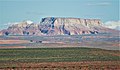
South aspect from Highway 98

Northwest aspect from Highway 98


Climate
According to the Köppen climate classification system, LeChee Rock is located in an arid climate zone with hot, very dry summers, and chilly winters with very little snow. Spring and fall are the most favorable seasons to visit.
Script error: No such module "weather box".
See also
- Colorado Plateau
- List of rock formations in the United States
References
- ↑ 1.0 1.1 1.2 1.3 1.4 "Leche-e Rock - 5,900' AZ". https://listsofjohn.com/peak/73895.
- ↑ 2.0 2.1 2.2 "LeChee Rock". United States Geological Survey. https://geonames.usgs.gov/apex/f?p=gnispq:3:::NO::P3_FID:6944.
- ↑ Yurth, Cindy (July 11, 2013). "On the Rim of Opportunity". Navajo Times. https://navajotimes.com/news/chapters/071113lec.php.
- ↑ Baars, Donald L. (2002). A Traveler's Guide to the Geology of the Colorado Plateau. University of Utah Press. p. 211.
- ↑ "Vocabulary in Native American Languages: Navajo Words". Native Languages of the Americas. http://www.native-languages.org/navajo_words.htm.
- ↑ "Climatography of the United States No. 20 (1971–2000)" (PDF). National Oceanic and Atmospheric Administration. 2004. http://cdo.ncdc.noaa.gov/climatenormals/clim20/az/026180.pdf.[yes|permanent dead link|dead link}}]
External links
- Weather forecast: National Weather Service
- LeChee Rock pronunciation
 |  |

