Earth:Hancock Butte (Arizona)
| Hancock Butte | |
|---|---|
 North aspect centered, from Point Imperial | |
| Highest point | |
| Elevation | 7,683 ft (2,342 m) [1] |
| Prominence | 463 ft (141 m) [1] |
| Parent peak | Mount Hayden (8,362 ft)[1] |
| Isolation | 0.81 mi (1.30 km) [1] |
| Coordinates | [ ⚑ ] : 36°15′42″N 111°58′29″W / 36.2617303°N 111.9747936°W [2] |
| Naming | |
| Etymology | William A. Hancock |
| Geography | |
Lua error in Module:Location_map at line 522: Unable to find the specified location map definition: "Module:Location map/data/Arizona" does not exist.
| |
| Location | Grand Canyon National Park Coconino County, Arizona, US |
| Parent range | Kaibab Plateau Colorado Plateau |
| Topo map | USGS Point Imperial |
| Geology | |
| Age of rock | Permian |
| Climbing | |
| First ascent | Alan Doty, October 1976 |
| Easiest route | class 5.1 climbing[1] |
Hancock Butte is a 7,683-foot-elevation (2,342-meter) summit located in the Grand Canyon, in Coconino County of northern Arizona, US.[2] It is situated one mile south of the Point Imperial viewpoint on the canyon's North Rim, where it towers 3,700 feet (1,100 meters) above Nankoweap Canyon. Its nearest higher neighbor is Mount Hayden, one mile to the north-northeast, Kibbey Butte is one mile to the south-southwest, and Brady Peak is 1.5 mile to the southeast. Hancock Butte is named after William A. Hancock (1831–1902), a pioneer and politician of the Arizona Territory known for performing the survey work required to create the town of Phoenix and erecting the first building there in 1870.[2] This geographical feature's name was officially adopted in 1932 by the U.S. Board on Geographic Names.[2] According to the Köppen climate classification system, Hancock Butte is located in a Cold semi-arid climate zone.[3]
Geology
Hancock Butte is a butte topped by Esplanade Sandstone, part of the Pennsylvanian-Permian Supai Group overlaying the cliff-forming Mississippian Redwall Limestone.[4] Precipitation runoff from this feature drains east into the Colorado River via Nankoweap Creek.
Gallery
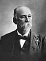
William Augustus Hancock
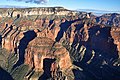
Aerial view with south aspect front and center, Mt. Hayden to right, Point Imperial centered at top

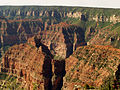
Mt. Hayden to left, Hancock Butte lower right
Hancock Butte lower left

Aerial view of Hancock Butte with Mt. Hayden behind it.


.jpg)
See also
- Geology of the Grand Canyon area
References
- ↑ 1.0 1.1 1.2 1.3 1.4 "Hancock Butte – 7,683' AZ". https://listsofjohn.com/peak/71571.
- ↑ 2.0 2.1 2.2 2.3 "Hancock Butte". United States Geological Survey. https://geonames.usgs.gov/apex/f?p=gnispq:3:::NO::P3_FID:5538.
- ↑ Peel, M. C.; Finlayson, B. L.; McMahon, T. A. (2007). "Updated world map of the Köppen−Geiger climate classification". Hydrol. Earth Syst. Sci. 11. ISSN 1027-5606.
- ↑ William Kenneth Hamblin, Anatomy of the Grand Canyon: Panoramas of the Canyon's Geology, 2008, Grand Canyon Association Publisher, ISBN:9781934656013.
External links
- Weather forecast: National Weather Service
 |  |

